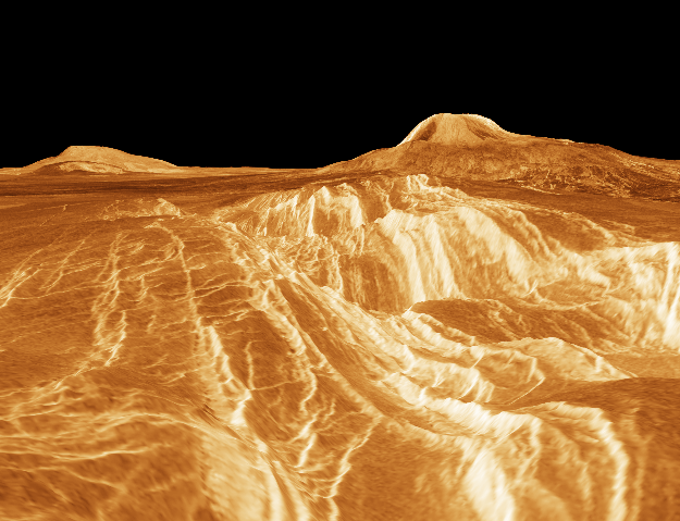
Color information from the Soviet Venera landers and radar data from the Magellan spacecraft were used to construct this striking perspective view of the Venusian landscape. (In this computer generated image, the vertical scale has been exagerated.) In the foreground is the edge of a rift valley created by faulting in the crust of Venus. The valley runs all the way to the base of Gula Mons, a 2 mile high volcano seen here on the right, some 450 miles in the distance. On the left is another volcano, Sif Mons. Using radar to pierce the dense clouds continuously shrouding the Face of Venus, Magellan was able to explore over 98% of the Venusian surface, revealing a a diverse and tantalizing topography.
La información de color proveniente de los módulos de aterrizaje soviéticos Venera y los datos de radar de la sonda espacial Magellan se utilizaron para construir esta impresionante vista en perspectiva del paisaje venusiano. (En esta imagen generada por computadora, la escala vertical ha sido exagerada.) En el primer plano se aprecia el borde de un valle de rift formado por fallas en la corteza de Venus. El valle se extiende hasta la base de Gula Mons, un volcán de 2 millas de altura visible a la derecha, a unas 450 millas de distancia. A la izquierda se encuentra otro volcán, Sif Mons. Utilizando el radar para atravesar las densas nubes que cubren continuamente la faz de Venus, Magellan pudo explorar más del 98% de la superficie venusiana, revelando una topografía diversa y fascinante.