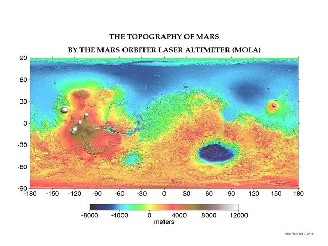
Mars has its ups and downs. Visible on the above interactive topographic map of the surface of Mars are giant volcanoes, deep valleys, impact craters, and terrain considered unusual and even mysterious. Particularly notable are the volcanoes of the Tharsis province, visible on the left in (false-color) red and white, which are taller than any mountains on Earth. Just to the left of center is Valles Marineris, a canyon much longer and deeper than Earth's Grand Canyon. On the right in blue is the Hellas Planitia, a basin over 2000 kilometers wide that was likely created by a collision with an asteroid. Mars has many smooth lowlands in the north, and many rough highlands in the south. This map was created by the Mars Orbital Laser Altimeter (MOLA) on board the robot Mars Global Surveyor currently orbiting Mars. MOLA measures heights on Mars by precisely determining the time it takes for a low power laser beam to bounce off the surface. Zoom in by clicking anywhere on the above map.
Marte tiene sus altibajos. En el mapa interactivo de topografía de la superficie de Marte, visible arriba, se pueden observar volcanes gigantes, valles profundos, cráteres de impacto y terrenos considerados inusuales e incluso misteriosos. Particularmente notables son los volcanes de la provincia de Tharsis, visibles a la izquierda en rojo y blanco (en color falso), que son más altos que cualquier montaña en la Tierra. Justo a la izquierda del centro se encuentra Valles Marineris, un cañón mucho más largo y profundo que el Gran Cañón de la Tierra. A la derecha, en azul, se encuentra la Planitia Hellas, un cuenco de más de 2000 kilómetros de ancho que probablemente fue creado por una colisión con un asteroide. Marte tiene muchas llanuras suaves en el norte, y muchas tierras altas rugosas en el sur. Este mapa fue creado por el Altimetro Láser Orbital de Marte (MOLA), a bordo del robot Mars Global Surveyor que actualmente orbita Marte. MOLA mide las alturas en Marte determinando con precisión el tiempo que tarda un haz láser de baja potencia en rebotar en la superficie. Haga zoom acercándose haciendo clic en cualquier parte del mapa anterior.