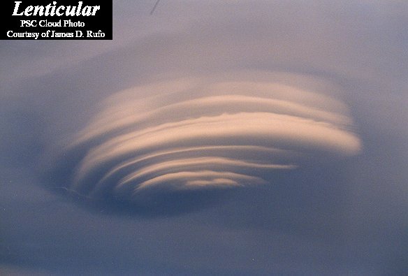
Why does this cloud look so strange? Actually, pictured above are several clouds all stacked up into one striking lenticular cloud. Normally, air moves much more horizontally than it does vertically. Sometimes, however, such as when wind comes off of a mountain or a hill, relatively strong vertical oscillations take place as the air stabilizes. The dry air at the top of an oscillation may be quite stratified in moisture content, and hence forms clouds at each layer where the air saturates with moisture. The result can be a lenticular cloud with a strongly layered appearance. The above picture was taken in 1999 over Plymouth, New Hampshire, USA. The same lenticular cloud also looks strange when photographed from 30 kilometers away.
¿Por qué esta nube tiene un aspecto tan extraño? En realidad, en la imagen anterior se observan varias nubes apiladas que forman una sola nube lenticular llamativa. Normalmente, el aire se mueve mucho más horizontalmente que verticalmente. Sin embargo, a veces, como cuando el viento desciende de una montaña o una colina, se producen oscilaciones verticales relativamente fuertes mientras el aire se estabiliza. El aire seco en la parte superior de una oscilación puede estar muy estratificado en contenido de humedad y, por lo tanto, forma nubes en cada capa donde el aire se satura de humedad. El resultado puede ser una nube lenticular con una apariencia fuertemente estratificada. La fotografía anterior fue tomada en 1999 sobre Plymouth, New Hampshire, EE.UU. La misma nube lenticular también parece extraña cuando se fotografía desde 30 kilómetros de distancia.