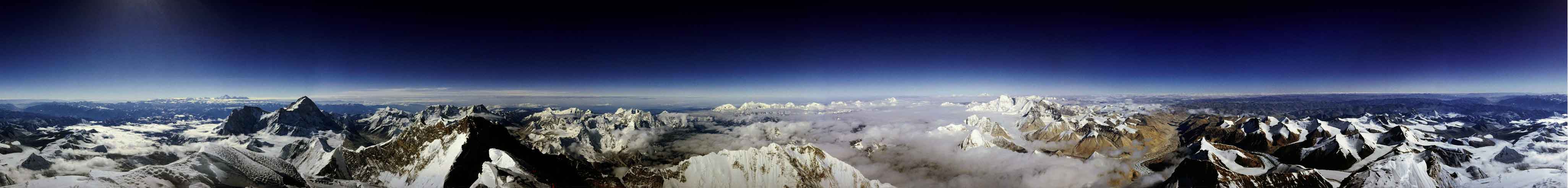
What would it be like to stand atop the tallest mountain on Earth? To see a full panoramic vista from there, scroll right. Visible are snow peaked mountains near and far, tremendous cliffs, distant plateaus, the tops of clouds, and a dark blue sky. Mt. Everest stands 8.85 kilometers above sea level, roughly the maximum height reached by international airplane flights, but much less than the 300 kilometers achieved by a space shuttle. Hundreds of people have tried and failed to climb the behemoth by foot, a feat first accomplished successfully in 1953. About 1000 people have now made it to the summit. Roddy Mackenzie, who climbed the mountain in 1989, captured the above image. Mt. Everest lies in the Himalaya mountains in the country of Nepal. In the native language of Nepal, the mountain's name is "Sagarmatha" which means "forehead of the sky."
¿Cómo sería estar en la cima de la montaña más alta de la Tierra? Para contemplar un panorama completo desde allí, desplácese hacia la derecha. Son visibles montañas con picos nevados cercanas y lejanas, imponentes acantilados, mesetas distantes, la parte superior de las nubes y un cielo azul oscuro. El monte Everest se eleva 8,85 kilómetros sobre el nivel del mar, aproximadamente la altitud máxima alcanzada por los vuelos de aviones comerciales internacionales, aunque muy por debajo de los 300 kilómetros que alcanzaba el transbordador espacial. Cientos de personas han intentado sin éxito escalarlo a pie, una hazaña lograda por primera vez en 1953. Alrededor de 1000 personas han conseguido llegar a la cima. Roddy Mackenzie, quien escaló la montaña en 1989, capturó la imagen anterior. El monte Everest se encuentra en la cordillera del Himalaya, en el país de Nepal. En el idioma nativo de Nepal, el nombre de la montaña es «Sagarmatha», que significa «frente del cielo».