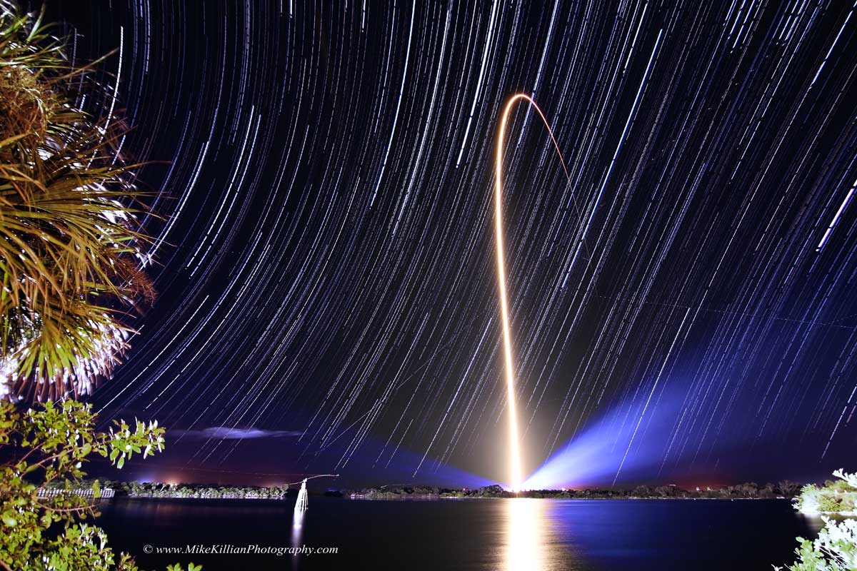
Fixed to a tripod and looking east across the Kennedy Space Center's Turn Basin, a camera captured these star trails as a series of short exposures over a three hour period on the evening of January 23rd. Positioned just a few miles from Space Launch Complex 41 at Cape Canaveral Air Force Station, it also captured a spectacular night launch of an Atlas V rocket carrying NASA's Tracking and Data Relay Satellite TDRS-L. Creating the trails, the apparent motion of the stars through the sky is just a reflection of the daily rotation of planet Earth on its axis. But that rotation is also the reason the rocket streak follows a path arcing east across the Atlantic. Launching toward the east, in the direction of Earth's rotation, adds the rotation velocity to the rocket and reduces the fuel needed to reach orbit. A little ironically, TDRS-L is destined for a geostationary orbit. From there, 36,000 kilometers or so above the equator, its orbital period will match Earth's rotation and the satellite will hang motionless in planet Earth's sky.
Fijada a un trípode y mirando hacia el este a través del Turn Basin del Centro Espacial Kennedy, una cámara capturó estos rastros estelares como una serie de exposiciones cortas durante un período de tres horas en la noche del 23 de enero. Ubicada a solo unas pocas millas de la Complejidad de Lanzamiento 41 en la Base Aérea de Cap Canaveral, también capturó el lanzamiento nocturno espectacular de un cohete Atlas V que transportaba el satélite de seguimiento y retransmisión de datos TDRS-L de la NASA. Los rastros estelares se crean debido al movimiento aparente de las estrellas en el cielo, que es simplemente una reflexión de la rotación diaria del planeta Tierra sobre su eje. Pero esa rotación también es la razón por la que la estela del cohete sigue un camino que se curva hacia el este sobre el Atlántico. Al lanzar hacia el este, en la dirección de la rotación terrestre, se suma la velocidad de rotación al cohete y se reduce la cantidad de combustible necesaria para alcanzar la órbita. Un poco irónicamente, el TDRS-L está destinado a una órbita geoestacionaria. Desde allí, aproximadamente a 36.000 kilómetros sobre el ecuador, su período orbital coincidirá con la rotación de la Tierra y el satélite permanecerá inmóvil en el cielo del planeta Tierra.