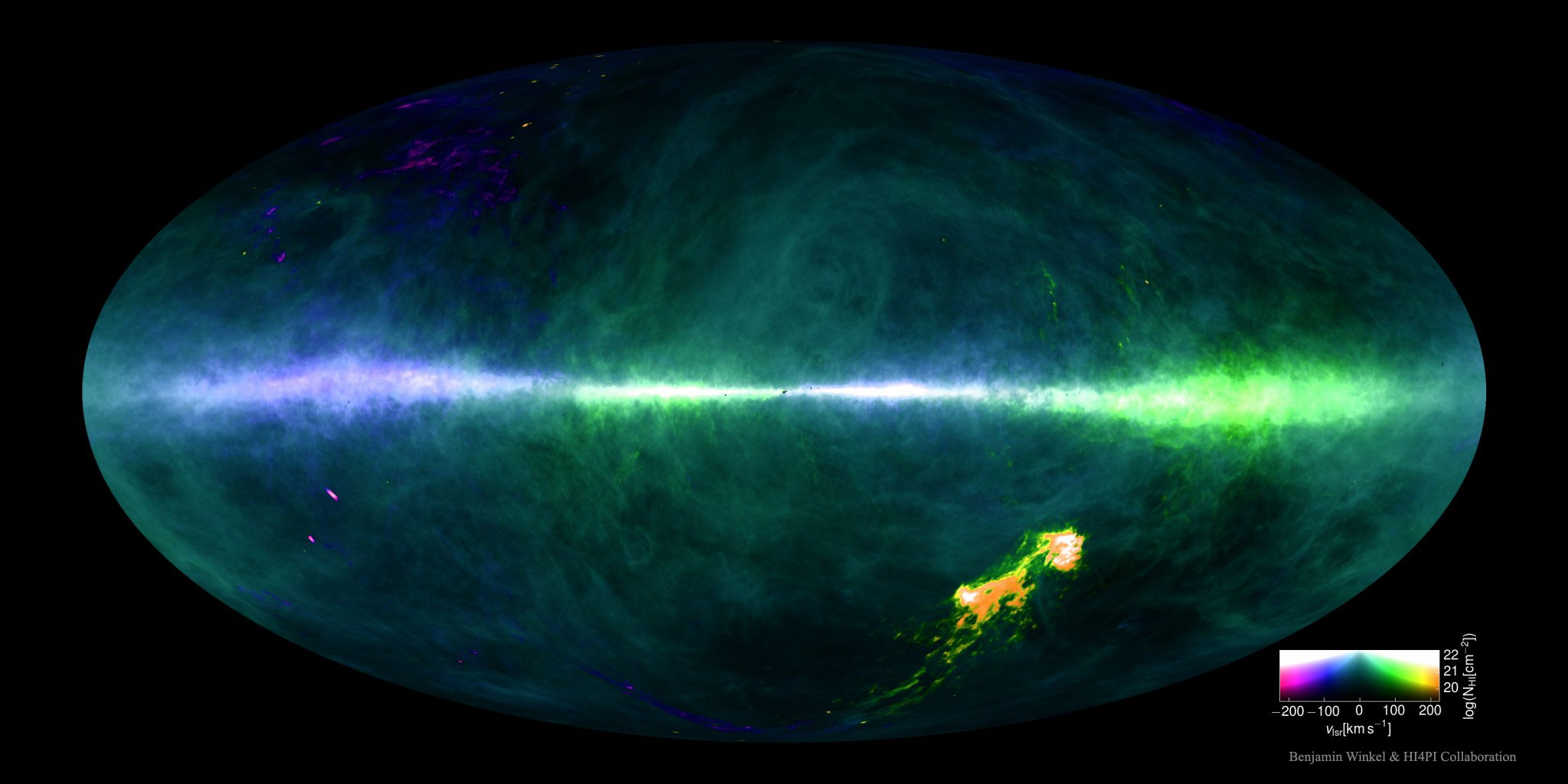
Where are the Milky Way's gas clouds and where are they going? To help answer this question, a new highest-resolution map of the sky in the universe's most abundant gas -- hydrogen -- has been completed and recently released, along with its underlying data. Featured above, the all-sky map of hydrogen's 21-cm emission shows abundance with brightness and speed with color. Low radial speeds toward us artificially colored blue and low radial speeds away colored green. The band across the middle is the plane of our Milky Way Galaxy, while the bright spots on the lower right are the neighboring Magellanic Clouds. The HI4PI map collects data from over one million observations with the northern Effelsberg 100-Meter Radio Telescope in Germany and the southern Parkes 64-Meter Radio Telescope in Australia, also known as "The Dish". The details of the map not only better inform humanity about star formation and interstellar gas in our Milky Way galaxy, but also how much light this local gas is likely to absorb when observing the outside universe. Many details on the map are not yet well understood.
¿Dónde se encuentran las nubes de gas de la Vía Láctea y hacia dónde se dirigen? Para ayudar a responder esta pregunta, se ha completado y recientemente publicado un nuevo mapa de la mayor resolución del cielo en el gas más abundante del universo: el hidrógeno, junto con sus datos subyacentes. El mapa mostrado arriba representa la emisión de 21 cm del hidrógeno en todo el cielo, mostrando su abundancia mediante el brillo y su velocidad mediante el color. Las velocidades radiales bajas hacia nosotros se muestran artificialmente en color azul y las velocidades radiales bajas alejándose en color verde. La banda que atraviesa el medio es el plano de nuestra galaxia, la Vía Láctea, mientras que los puntos brillantes en la parte inferior derecha son las Nubes Magellánicas vecinas. El mapa HI4PI recopila datos de más de un millón de observaciones realizadas con el telescopio de radio Effelsberg de 100 metros en el norte, Alemania, y el telescopio de radio Parkes de 64 metros en el sur, Australia, también conocido como "The Dish". Los detalles del mapa no solo proporcionan información más precisa sobre la formación estelar y el gas interestelar en nuestra galaxia, la Vía Láctea, sino también sobre cuánta luz es probable que este gas local absorba al observar el universo exterior. Muchos detalles en el mapa aún no se comprenden bien.