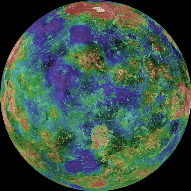
If the thick clouds covering Venus were removed, how would the surface appear? Using an imaging radar technique, the Magellan spacecraft was able to lift the veil from the Face of Venus and produce this spectacular high resolution imageof the planet's surface. Red, in this false-color map, represent mountains, while blue represents valleys This 3-kilometer resolution map is a composite of Magellan images compiled between 1990 and 1994. Gaps were filled in by the Earth-based Arecibo Radio Telescope. The large yellow/red area in the north is Ishtar Terra featuring Maxwell Montes, the largest mountain on Venus. The large highland regions are analogous to continents on Earth. Scientists are particularly interested in exploring the geology of Venus because of its similarity to Earth. Information: Thursday, September 26 - A Total Lunar Eclipse
Si se eliminaran las densas nubes que cubren Venus, ¿cómo se vería su superficie? Utilizando una técnica de radar de imágenes, la sonda espacial Magallanes (Magellan) logró levantar el velo sobre el rostro de Venus y producir esta espectacular imagen de alta resolución de la superficie del planeta. En este mapa en falso color, el rojo representa montañas, mientras que el azul representa valles. Este mapa con una resolución de 3 kilómetros es un compuesto de imágenes de la misión Magellan recopiladas entre 1990 y 1994. Los vacíos fueron completados con datos del Radiotelescopio Arecibo, situado en la Tierra. La gran área amarilla y roja en el norte corresponde a Ishtar Terra, que alberga Maxwell Montes, la montaña más alta de Venus. Las grandes regiones elevadas son análogas a los continentes de la Tierra. Los científicos tienen especial interés en explorar la geología de Venus debido a su similitud con la Tierra. Información: Jueves, 26 de septiembre - Un Eclipse Total de Luna