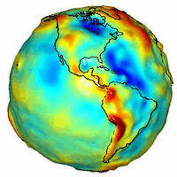
Why do some places on Earth have higher gravity than others? Sometimes the reason is unknown. To help better understand the Earth's surface, slight distance changes between a pair of identically orbiting satellites named GRACE have been used to create the best ever map of Earth's gravitational field. High points on this map, also colored red, indicate areas where gravity is slightly stronger than usual, while in blue areas gravity is slightly weaker. Many bumps and valleys on the map can be attributed to surface features, such as the North Mid-Atlantic Ridge and the Himalayan Mountains, but others cannot, and so might relate to unusually high or low sub-surface densities. Maps like this also help calibrate changes in the Earth's surface including variable ocean currents and the melting of glaciers.
¿Por qué algunos lugares en la Tierra tienen una gravedad más fuerte que otros? A veces la razón es desconocida. Para ayudar a comprender mejor la superficie terrestre, se han utilizado los ligeros cambios de distancia entre un par de satélites idénticamente orbitales llamados GRACE para crear el mejor mapa jamás realizado del campo gravitacional de la Tierra. Los puntos elevados en este mapa, también coloreados en rojo, indican áreas donde la gravedad es ligeramente más fuerte de lo habitual, mientras que en las áreas azules la gravedad es ligeramente más débil. Muchas protuberancias y valles del mapa pueden atribuirse a características superficiales, como la Dorsal Mediatlántica y las Montañas del Himalaya, pero otras no pueden, y por lo tanto podrían relacionarse con densidades subsuperficiales inusualmente altas o bajas. Mapas como este también ayudan a calibrar cambios en la superficie terrestre, incluyendo las corrientes oceánicas variables y el derretimiento de glaciares.